After scouring various Topo maps of the Wanaka area in search of a
suitable adventure, I settled on a route that began just off the road at
the top of the Crown Range and sidled it's way up and into the
distance. The map told me that the route looped out into the Pisa Range
and then linked up to the Roaring Meg Pack Track descent, one I barely
remember from a heli-trip years earlier. I love maps. Much to my
partner's disgust, I can spend hours with maps spread across the floor,
mapping courses, then re-mapping them when I find another trail to add.
Sometimes, I spend so much time late into the night fantasising over the
route I have plotted, that when I finally come to ride it, there is
this bizarre link that automatically forms between the images I see, the
things I feel, the experiences I have, and the map... Right now I could
run my finger along the track that traverses the ridge up to the
highpoint and show you exactly where the snowed-in road lay, and the
magical rocky descent, and the strange aviation navigation equipment on
the mountain peak. I could point out the spot where I felt lonely, or
the exact moment a broad smile appeared on my face as I hammered down a
descent, realising this was the most fun I'd had in ages.

 So
I set off at a very respectable hour. My partner's mum had very kindly
offered to drop me off at the start of the track and pick me up at the
end, but I insisted that the extra 25km each way from Wanaka to Cardrona
would be good training (just quietly, it is a pretty boring stretch of
road, but I really didn't expect my partner's family to shuttle me
around for the sake of a mere 25km in each direction). The road ride on
my mountain bike from Wanaka to the top of the Crown Range saddle took
me about 2 hours, and apart from the final 2-3km, where the gradient
pitched up a little more steeply, was a relatively mellow climb to about
1000m.It was then time to head off the road, away from the traffic and
tarmac, and towards the real hills, the dirt... and the snow.
So
I set off at a very respectable hour. My partner's mum had very kindly
offered to drop me off at the start of the track and pick me up at the
end, but I insisted that the extra 25km each way from Wanaka to Cardrona
would be good training (just quietly, it is a pretty boring stretch of
road, but I really didn't expect my partner's family to shuttle me
around for the sake of a mere 25km in each direction). The road ride on
my mountain bike from Wanaka to the top of the Crown Range saddle took
me about 2 hours, and apart from the final 2-3km, where the gradient
pitched up a little more steeply, was a relatively mellow climb to about
1000m.It was then time to head off the road, away from the traffic and
tarmac, and towards the real hills, the dirt... and the snow.
 As
I climbed Rock Peak track, the road disappeared into the distance, as
did the stunning view of Queenstown which sat behind me. The climb was
significant... Quite steep, unrelenting, rocky and loose. Occasionally, I
would get some respite from the climb as the gradient eased and then
pitched up again. Rock Peak became a very visible landmark in front of
me, and before long, I arrived at an intersection with a sign pointing
one way towards Tuohy's Gully, and the other towards the Rock Peak
summit. I figured that I had come far enough that it would be silly not
to climb the final 100m and see the summit, so I rode/hike-a-biked up
the final steep section of track to the Rock Peak summit, 1530m above
sea level to find an array of aviation navigational equipment sitting
atop the hill. One of the devices had a rather large sign on it that
said "Navigation aid critical to aircraft safety". I thought it a little
odd that such important equipment would be positioned in a place so
easy to get to, and completely unfenced... But then reminded myself that
I had just climbed another 600m off the road, to a place not accessible
by vehicle, and realised that anyone interested in causing trouble
would likely not be bothered with the grueling climb along the rough
gravel road and would probably find an easier place to make their
mischief. I nestled myself out of the wind, sheltered by a rock to enjoy
my lunch with a view, watching planes float past as they came in to
land at Queenstown Airport.
As
I climbed Rock Peak track, the road disappeared into the distance, as
did the stunning view of Queenstown which sat behind me. The climb was
significant... Quite steep, unrelenting, rocky and loose. Occasionally, I
would get some respite from the climb as the gradient eased and then
pitched up again. Rock Peak became a very visible landmark in front of
me, and before long, I arrived at an intersection with a sign pointing
one way towards Tuohy's Gully, and the other towards the Rock Peak
summit. I figured that I had come far enough that it would be silly not
to climb the final 100m and see the summit, so I rode/hike-a-biked up
the final steep section of track to the Rock Peak summit, 1530m above
sea level to find an array of aviation navigational equipment sitting
atop the hill. One of the devices had a rather large sign on it that
said "Navigation aid critical to aircraft safety". I thought it a little
odd that such important equipment would be positioned in a place so
easy to get to, and completely unfenced... But then reminded myself that
I had just climbed another 600m off the road, to a place not accessible
by vehicle, and realised that anyone interested in causing trouble
would likely not be bothered with the grueling climb along the rough
gravel road and would probably find an easier place to make their
mischief. I nestled myself out of the wind, sheltered by a rock to enjoy
my lunch with a view, watching planes float past as they came in to
land at Queenstown Airport.
 The
previous day, a rather nasty front of weather had passed through to see
in the New Year, and Wanaka and Queenstown had enjoyed (or endured) a
large, unseasonal dump of snow down to about 900m. The hot Summer sun
had melted the snow away to all but a few patches from what I could see,
which was reassuring given my route had three more substantial peaks to
traverse... Mount Allen, at 1492m, Quartz Knoll, at 1593m, and
Queensberry Hill at 1581m. It was a relief to be out on my bike again,
enjoying the outdoors after the previous couple of day's bad
weather.After finishing my lunch, I descended Rock Peak, and continued
on towards Tuohy's Gully. Credit really does have to be given here to
DOC. Whilst I was carrying a map, I rarely needed it. Every intersection
was signposted and marked. On a bit of a side note, too, another great
thing about the Wanaka/Queenstown area is that most tracks are dual use
(which encompasses the majority of tracks worth riding anyway), which
makes for some exceptional back country trips by bike.
The
previous day, a rather nasty front of weather had passed through to see
in the New Year, and Wanaka and Queenstown had enjoyed (or endured) a
large, unseasonal dump of snow down to about 900m. The hot Summer sun
had melted the snow away to all but a few patches from what I could see,
which was reassuring given my route had three more substantial peaks to
traverse... Mount Allen, at 1492m, Quartz Knoll, at 1593m, and
Queensberry Hill at 1581m. It was a relief to be out on my bike again,
enjoying the outdoors after the previous couple of day's bad
weather.After finishing my lunch, I descended Rock Peak, and continued
on towards Tuohy's Gully. Credit really does have to be given here to
DOC. Whilst I was carrying a map, I rarely needed it. Every intersection
was signposted and marked. On a bit of a side note, too, another great
thing about the Wanaka/Queenstown area is that most tracks are dual use
(which encompasses the majority of tracks worth riding anyway), which
makes for some exceptional back country trips by bike.
 As
I made my way further into the Pisa Range, the climbs became steeper,
forcing me off the bike on occasion, but totally worth the effort. As I
rounded the summit of Mount Allen, I was able to see across the range
down into the valley where Wanaka lay. I doubt there are many
opportunities in the area to enjoy views of both Queenstown and Wanaka.
The wind howled around me, and the combination of climbing and
descending meant I was in a constant state of indecision as to whether
my jacket stayed on or off.
As
I made my way further into the Pisa Range, the climbs became steeper,
forcing me off the bike on occasion, but totally worth the effort. As I
rounded the summit of Mount Allen, I was able to see across the range
down into the valley where Wanaka lay. I doubt there are many
opportunities in the area to enjoy views of both Queenstown and Wanaka.
The wind howled around me, and the combination of climbing and
descending meant I was in a constant state of indecision as to whether
my jacket stayed on or off.
 As
I peered across the range, I could see a very visible line of snow
which followed the ridge line up to the peak next closest to me. I
remember thinking to myself "I really hope that isn't the road I am
meant to be following". As I drew closer, I realised it was. Evidently,
this side of the range didn't receive as much sun as the other, and the
snow from the previous day had not yet melted... Furthermore, as I
reached the snow, I noticed that it seemed to follow the lay of the road
the whole way up (I guess that because the road has been built in such a
way that it is protected from the elements, it also meant that the snow
was protected from the elements as it lay on the road). Attempts to
follow a line up the edge of the track, where the snow wasn't so thick,
were occasionally successful, but often foiled by steep embankments off
the edge of the road, or times when the snow would drift off to the
side, drawing me 100-200m off the track before realising I had to cross
the (often quite deep) snow drift to rejoin the track so I didn't become
lost.
As
I peered across the range, I could see a very visible line of snow
which followed the ridge line up to the peak next closest to me. I
remember thinking to myself "I really hope that isn't the road I am
meant to be following". As I drew closer, I realised it was. Evidently,
this side of the range didn't receive as much sun as the other, and the
snow from the previous day had not yet melted... Furthermore, as I
reached the snow, I noticed that it seemed to follow the lay of the road
the whole way up (I guess that because the road has been built in such a
way that it is protected from the elements, it also meant that the snow
was protected from the elements as it lay on the road). Attempts to
follow a line up the edge of the track, where the snow wasn't so thick,
were occasionally successful, but often foiled by steep embankments off
the edge of the road, or times when the snow would drift off to the
side, drawing me 100-200m off the track before realising I had to cross
the (often quite deep) snow drift to rejoin the track so I didn't become
lost.
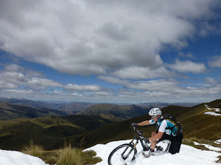
 It
was all a bit novel at first, and I spent some time taking photos and
making snow angels, but it made climbing these final two peaks super
hard work. The road was a metre deep in snow (deeper in some places),
and as I climbed higher, I was forced to plow my way through the snow on
a couple of occasions, sinking in up to my waist as I dragged my bike
behind me. On one occasion, my legs went numb from the snow against my
legs, and I wished I had spent less time mucking around in it lower
down. Those things aside, though, it was stunning... And I was in no
rush... But there was a certain degree of somberness surrounding me. I
felt like I was miles away from anywhere, and as the wind howled across
the peaks and the grey clouds skirted across the blue sky, it felt eerie
been up there by myself. Like I wasn't supposed to be there... A
distinct uneasiness that I tried to dismiss by basking in the pleasure
of experience itself.
It
was all a bit novel at first, and I spent some time taking photos and
making snow angels, but it made climbing these final two peaks super
hard work. The road was a metre deep in snow (deeper in some places),
and as I climbed higher, I was forced to plow my way through the snow on
a couple of occasions, sinking in up to my waist as I dragged my bike
behind me. On one occasion, my legs went numb from the snow against my
legs, and I wished I had spent less time mucking around in it lower
down. Those things aside, though, it was stunning... And I was in no
rush... But there was a certain degree of somberness surrounding me. I
felt like I was miles away from anywhere, and as the wind howled across
the peaks and the grey clouds skirted across the blue sky, it felt eerie
been up there by myself. Like I wasn't supposed to be there... A
distinct uneasiness that I tried to dismiss by basking in the pleasure
of experience itself.

 I
was forced to descend most of Quartz Knoll on foot, too... Any
opportunity I did get to ride was stopped short by my front wheel
burying itself in a deep patch of snow. Finally I crested Queensberry
Hill and started descending the other side. I was at about 1600m and
there was little in the way of climbing from this point on. As I worked
my way down the mountain, the snow gradually gave way to a slurry of mud
created by snow melt and dirt, and the air started to warm up. The snow
melt finally disappeared, laying in front of me about 1300m of dry,
rocky descent to enjoy. The final rocky descent into Tuohy's Gully was
great fun, and then on to the Roaring Meg Pack Track, which travels over
rough, rocky steep DOC land and farmland to arrive in the Cardrona
Valley. The Ninja chewed up the descent with ease as I glided over
rocks, through gullies and rivers. It was, in all honesty, the most fun
I'd had on my bike in a loooong time, and I couldn't wipe the smile off
my face, nor dismiss the disappointment that washed over me when I
finally popped back out onto the highway.
I
was forced to descend most of Quartz Knoll on foot, too... Any
opportunity I did get to ride was stopped short by my front wheel
burying itself in a deep patch of snow. Finally I crested Queensberry
Hill and started descending the other side. I was at about 1600m and
there was little in the way of climbing from this point on. As I worked
my way down the mountain, the snow gradually gave way to a slurry of mud
created by snow melt and dirt, and the air started to warm up. The snow
melt finally disappeared, laying in front of me about 1300m of dry,
rocky descent to enjoy. The final rocky descent into Tuohy's Gully was
great fun, and then on to the Roaring Meg Pack Track, which travels over
rough, rocky steep DOC land and farmland to arrive in the Cardrona
Valley. The Ninja chewed up the descent with ease as I glided over
rocks, through gullies and rivers. It was, in all honesty, the most fun
I'd had on my bike in a loooong time, and I couldn't wipe the smile off
my face, nor dismiss the disappointment that washed over me when I
finally popped back out onto the highway.


I cruised the 25km home to Wanaka for a well-earned feast and a bath, stoked to have experienced another memorable adventure.


I cruised the 25km home to Wanaka for a well-earned feast and a bath, stoked to have experienced another memorable adventure.

Awesome work! (I just read this 7 odd years later) ;)
ReplyDelete